Daily Water Command
Localized water intelligence for the way you actually plan a day on the water.
Checking local water…
Today's Best Plan
- Waiting on enough data to build a usable plan.
Why this read
- As soon as weather, water, traffic, and regulations load, this panel will show what the brief is leaning on.
Loading local pattern pack…
Building feeding windows…
Waiting on a saved prior read…
Loading gear recommendation…
On the Water
Weather, water behavior, best windows, and route thinking for your selected water
Generating water read…
Loading…
Loading forecast…
Animated weather and marine context centered on your selected water. Select a layer below.
NOAA probability-of-encounter maps for Chrysaora chesapeakei — the Chesapeake Bay sea nettle. Most abundant in middle Bay tributaries where salinity runs 10–20 ppt. Updated daily from NOAA NCCOS model runs.
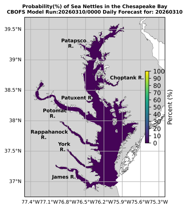

What this means from Shady Side: Sea nettles are most common June through September when water temperatures exceed 78°F and salinity is in the 10–20 ppt range. The middle Bay tributaries — West River, South River, Rhode River — are prime nettle habitat. Higher probability doesn't mean guaranteed stings, but plan accordingly for swimming and crabbing.
Practical notes: Nettles concentrate near the surface in calm water and along current lines. Windy days and moving water can disperse them. Early season (June) is usually lighter; peak is July–August. Vinegar helps with stings — not freshwater.
Route Thinking by ZoneOpen for route, shoreline, and exposure notes by zone.
Live Vessel Traffic
Commercial movement, bridge approaches, and why traffic matters to small boats
AIS vessel tracking centered on Thomas Point, Annapolis, and the Bay Bridge corridor. If your browser blocks the embed, use the direct links below.
Why Traffic Matters to Small BoatsOpen for the full small-boat traffic explainer.
Big commercial vessels do not stop quickly, cannot turn on a dime, and often have major blind spots ahead of the bow and along both sides. Even when they look far away, their speed, displacement, and wake can create real risk for a small boat, skiff, or center console.
Wherever you boat, pay extra attention in these four traffic environments:
Current, structure, narrow spans, and converging boat traffic compress decision time. Avoid lingering in marked navigation spans and give larger vessels the room they need to stay in the channel.
Ferries, charter boats, fuel dock traffic, sailboats, paddlers, and local traffic often stack into the same choke point. Expect crossing traffic, changing speeds, and limited sight lines.
When you need to cross a shipping or ferry route, do it decisively, cross at as close to a right angle as practical, and spend as little time in the lane as possible. Never assume the bigger vessel can or will move for you.
Tugs, barges, ferries, pilot boats, fishing boats, and service craft often follow predictable deep-water or dredged routes close to recreational water. Build the traffic picture early, monitor VHF where appropriate, and avoid getting pinned between wake, current, shoals, and hard structure.
Watch
Three region-specific YouTube picks for boating and fishing in your local water.
Loading camera sources…
Fishing Intelligence
Stripers, perch, specks, catfish, and practical Bay logic by season and zone
Generating outlook…
Loading moon data…
Crabbing Intelligence
Tide windows, gear, size rules, and what matters on a normal Bay day
Maps & Charts
Ramps, marinas, fuel, anchorages, fishing zones, and crabbing water
Click any marker for details. Use the coordinate picker to get lat/lng for adding new POIs.
Seasonal Bay Almanac
A field-guide timeline of the year on the water — from Shady Side to the bridge
AlmanacsOpen for the seasonal field guide and annual water rhythm.
Bay BOLO
Invasive species, hazards, and stewardship reminders
Boating Safety & Regulations
Navigation rules, required equipment, vessel awareness, and state-aware regulations
Boating SafetyOpen for navigation rules, sound signals, and required gear.
The basics every operator should know before leaving the dock. Based on USCG Navigation Rules and COLREGS. Not a substitute for a boating safety course — but a quick-reference for the rules that matter most on the Chesapeake.
Both boats steer to starboard (right) and pass port-to-port. This is the default for two power vessels approaching each other.
The boat on your right is the stand-on vessel — it holds course and speed. You are the give-way vessel and must pass behind it.
The vessel being passed always has the right of way. The passing vessel must stay clear and bear full responsibility.
Power-driven vessels must yield to sailing vessels — unless the sailboat is overtaking. Power also yields to vessels not under command, restricted in ability to maneuver, and vessels engaged in fishing.
Operate at a speed that allows you to take proper action to avoid collision. Comply with no-wake zones — fully off plane, minimal wake. Conditions, visibility, traffic density, and your stopping distance all factor in.
Short blast ≈ 1 second. Prolonged blast ≈ 4–6 seconds. Required in restricted visibility and during maneuvering situations.
I intend to alter course to starboard (pass on your port side).
I intend to alter course to port (pass on your starboard side).
Danger signal — I do not understand your intentions or disagree with your maneuver.
Warning signal — approaching a bend, leaving a dock, or restricted visibility.
One USCG-approved PFD for each person on board. Must be accessible — not buried in a locker. Properly sized. Children under 13 must wear them.
Type IV throwable — buoyant cushion or ring buoy. Required on boats 16 feet and over. Must be immediately available, not stowed.
Whistle or horn. Required on all vessels. Boats 39.4 feet and over need both a whistle and a bell.
Marine-grade, USCG-approved. Required on boats with enclosed engine compartments, fuel tanks, or enclosed living spaces. Check expiration and charge.
Required on coastal waters for boats 16 feet and over. Three day signals and three night signals (flares), or a single USCG-approved day/night electronic signal.
Required from sunset to sunrise and in restricted visibility. Red (port), green (starboard), white stern, and masthead lights per vessel type.
Waterproof reference cards worth keeping on board.
Waterproof card covering buoy shapes, colors, light patterns, and lateral/cardinal mark systems.
View on Amazon ↗Compact waterproof card with COLREGS rules, right-of-way diagrams, and sound signal reference.
View on Amazon ↗Loading state resources…